
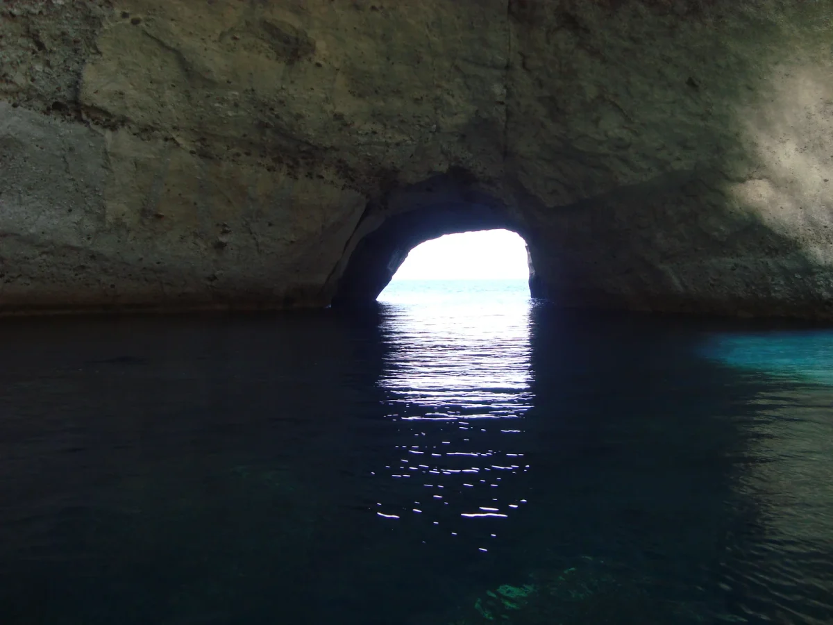
Milos is a volcanic island, and the sea has spent a few million years carving its soft white rock into arches, tunnels and caverns. The most spectacular of these sea caves, Sykia with its collapsed roof, the pirate caves of Kleftiko, the hidden coves of uninhabited Poliegos, have no road, no path and no ticket booth. The only way in is from the water. This guide covers every cave worth your fuel, where it sits on the map, how long it takes from our base at Agia Kiriaki, and which boat from our fleet gets you there safely.
Key Takeaways
- Sykia and Kleftiko sit side by side on the south-west coast, about 3 nautical miles apart, and both are boat-only. They are the two caves you should not leave Milos without seeing.
- Papafragas and the Glaronisia basalt islets are on the north coast, near Pollonia. Poliegos, the largest uninhabited island in the Aegean, is 15 minutes by fast boat from Pollonia.
- A half-day rental (5 hours) covers one cluster. To see the south-west caves and Poliegos in one trip you need a full day, and ideally the Compass 7s with our captain.
- Wind decides everything. Check the forecast with us the morning of your rental: the west coast is exposed to the summer meltemi, the east and north coasts are usually calmer.
- You do not need a licence for the Compass 150cc (30 hp). For the 165cc you need a speedboat licence or one of our skippers.
Contents
- Why Milos has so many sea caves
- Sykia Cave: the cave with no roof
- Kleftiko: arches, tunnels and pirate history
- Gerontas and the south coast arches
- Papafragas: the narrow inlet on the north coast
- Glaronisia: basalt columns in the sea
- Poliegos: caves and the Blue Bay of an empty island
- Map and sample routes
- Which boat for which caves
- Safety inside and around caves
- FAQs
Why Milos has so many sea caves
Milos is the product of volcanic activity, and most of its coastline is made of tuff, pumice and other light volcanic rock. This rock is soft enough for waves to hollow out, but firm enough to hold an arch or a ceiling in place for centuries. Add the chemical action of seawater, winter storms from the south and west, and you get a coastline riddled with caves, natural bridges and collapsed chambers.
The same geology explains the colours. White Kleftiko, the rust reds and yellows of Poliegos, the black basalt of Glaronisia, all within a few miles of each other, all visible from the deck of a small boat. It is why renting a boat here is not a nice extra but the main event. Our guide to the best beaches in Milos you can only reach by boat covers the sandy side of that story; this one is about the rock.
Sykia Cave: the cave with no roof
Sykia (also written Sikia) is the cave that appears on every Milos postcard, even if people do not know its name. It is a large circular chamber on the south-west coast whose ceiling collapsed long ago, leaving a round opening to the sky. Sunlight pours through the hole, hits the water inside and turns the whole cavern emerald green, which is why some locals call it the Emerald Cave.
Key facts:
- Location: south-west coast, roughly 3 nautical miles north of Kleftiko, about 30 to 40 minutes from our base at Agia Kiriaki beach. There are no roads or footpaths, access is by sea only.
- Entrance: a natural arch about 20 metres wide and 5 metres high. Small boats can enter on a calm day; inside, the chamber rises over 30 metres to the open top.
- Inside: a tiny pebble beach at the back where you can step off and swim. The water is noticeably colder than outside.
- Best light: late afternoon, when the sun angles through the opening. Mornings are calmer for the crossing, so most people choose calm over colour.
With the Compass 7s, our captain will take you in, let you swim, and position the boat for photos. With a self-drive Compass, idle at the entrance, assess the swell, and only enter if the water inside is flat. Never enter with the engine off.
Kleftiko: arches, tunnels and pirate history
Kleftiko sits on the south-west tip of Milos, a cluster of white volcanic cliffs pierced by arches and tunnels you can swim or kayak through. The name comes from “kleftis”, thief: the coves hid pirate ships in medieval times, out of sight of the Venetian and Ottoman patrols.
We have written a dedicated complete guide to Kleftiko with timings, what you will see and the best time of day, so here is the short version that matters for cave hunters:
- From our base at Agia Kiriaki beach on the south coast it is about 6 nautical miles west: 20 to 30 minutes in the Compass 165cc or 7s, 40 to 50 minutes in the 30 hp Compass 150cc. Tour boats from Adamas take 1.5 to 2 hours.
- The main attractions are the large arch, the two swim-through tunnels and the big cave on the western side. Visibility underwater often exceeds 20 metres.
- Kleftiko and Sykia are almost always done together. Leave Agia Kiriaki early, reach Kleftiko while the tour boats from Adamas are still en route, then continue to Sykia and come back along the south coast.
Gerontas and the south coast arches
Between Agia Kiriaki and Kleftiko the south coast is lined with smaller formations that tour boats skip. Gerontas is the best of them: a wide beach backed by white cliffs, with a natural stone arch standing in the water off its western end. Further along you pass the white cliffs of Tsigrado and Firiplaka, where the rock has been eroded into overhangs and shallow grottos you can nose the boat under.
These are the “free” caves of a Kleftiko day. They cost no extra time because they sit on the route, and on a calm morning they give you a preview of what is waiting further west.
Papafragas: the narrow inlet on the north coast
Papafragas is on the north coast near the ancient city of Phylakopi, a few minutes east of Pollonia by boat. It is not a single cave but a narrow, fjord-like inlet cut deep into the cliffs, with a strip of sand at the far end and dark sea caves opening off both sides. From the sea it looks like a crack in the rock; from the top of the cliffs it looks like a natural swimming pool.
On land there is a steep path down and a small parking area, so it is one of the few caves you can also reach on foot. By boat you get the opposite view: you approach the mouth of the inlet, and the three smaller caves beside it, with the cliffs towering overhead. Do not take a boat inside the inlet itself, it is too narrow and swimmers use it. Anchor outside and swim in.
Glaronisia: basalt columns in the sea
Just off the north coast near Pollonia, the Glaronisia (“seagull islands”) are four small islets made entirely of hexagonal basalt columns, around 20 metres high, formed when lava cooled and cracked into prisms. They look like a Greek version of the Giant’s Causeway rising straight out of the sea. There is a sea cave on the largest islet that you can swim into, and the vertical walls are home to the seagulls that give the place its name.
Glaronisia pairs naturally with Papafragas and Poliegos into a north coast day.
Poliegos: caves and the Blue Bay of an empty island
Poliegos is the wild card of the Milos group. At about 18 square kilometres it is the largest uninhabited island in the Aegean, protected under Natura 2000, owned mostly by the Church and inhabited only by goats (the name means “many goats”) and a colony of Mediterranean monk seals that breed in its sea caves.
It lies 2 km south-east of Kimolos and about 6 km east of Milos. From Pollonia a fast boat reaches the first bay in around 15 minutes. What you find:
- Blue Bay (Galazia Nera): a shallow cove of white sand and turquoise water enclosed by limestone cliffs, the most photographed spot on the island.
- Mersini: the largest beach, on the sheltered south side, with calm water and good anchoring.
- Sea caves: dozens of them along the cliffs, several with collapsed ceilings that act as natural skylights. Some are monk seal habitat: look from the boat, do not enter caves where you see seals.
- Cliffs: volcanic mineral deposits colour the rock red, green, yellow and orange, very different from white Milos.
- Lighthouse: on the island’s highest point, reachable by a narrow footpath if you anchor below and have the legs for it.
Poliegos is usually combined with a circuit of Kimolos. Our Kimolos island guide covers the beaches on that side.
Map and sample routes
Two clusters, two different days. Trying to do both in one half-day rental does not work.
| Route | Caves covered | From Agia Kiriaki | Recommended boat |
|---|---|---|---|
| Kleftiko and Sykia | Gerontas, Kleftiko arches and tunnels, Sykia | Half day (165cc/7s) or full day with more swim time | Compass 7s with captain; Compass 165cc; Compass 150cc on a calm morning, ask us |
| South coast short | Gerontas arch, Firiplaka and Tsigrado overhangs | Half day, 5 to 15 minutes between stops | Compass 150cc or 165cc |
| West coast and caves | Kleftiko, Sykia, Kalogries, the roadless west coast | Full day | Compass 7s with captain, Compass 165cc |
| Kimolos and Poliegos | Karras cave, Poliegos caves, Blue Bay, Mersini | Full day from Agia Kiriaki (45 to 60 min each way), or half day with pick-up at Pollonia on request | Compass 165cc or 7s |
| North coast | Papafragas, Glaronisia | Full day, or with pick-up at Pollonia | Compass 7s with captain |
Geography is the reason. Our base at Agia Kiriaki is on the south coast, which puts Kleftiko and Sykia 20 to 40 minutes to the west and the south coast coves minutes away. Pollonia, Kimolos and Poliegos are on the opposite, north-east side of the island, 45 minutes to an hour by fast boat, which is why we can arrange pick-up at Pollonia or Psathi (Kimolos) on request for those routes. Read our half-day vs full-day comparison if you are deciding between the two formats.
Which boat for which caves
- Compass 150cc (30 hp, 5 people, no licence): perfect for the south coast coves within minutes of Agia Kiriaki, and on a calm morning it reaches Kleftiko and Sykia in 40 to 50 minutes; ask us on the day. Poliegos and the north coast are too far for it from the south coast. Read more on renting a boat in Milos without a licence.
- Compass 165cc (115 hp, 6 people, licence or skipper): fast enough for Kleftiko and Sykia on a calm day, and for the Kimolos and Poliegos circuit. If you do not hold a speedboat licence we provide a skipper.
- Compass 7s (250 hp, 8 people, always with our captain): the cave boat. The captain knows every entrance, handles the swell, and the all-inclusive package (snorkelling gear, GoPro footage, drinks, snacks, local wine) means you do nothing but swim.
Safety inside and around caves
- Wind first. The summer meltemi blows from the north and wraps around the west coast in the afternoon. Leave early, plan to be back on the sheltered side by mid-afternoon, and ask our team at the dock for the day’s forecast before you commit to a route.
- Never enter a cave with the engine off or with swimmers in the water next to the hull. Idle in, assess, idle out.
- Swell inside a cave is bigger than outside. If the water at the entrance is moving, stay out and swim in instead.
- Anchoring: sandy bottoms only, never on seagrass (posidonia) meadows, which are protected and hold the anchor badly anyway.
- Monk seals: Poliegos caves are a breeding area. A seal on a beach or in a cave means you back off quietly.
- Fuel: caves are at the far ends of the island. The 150cc carries 50 litres, the 165cc 90 litres. Fuel is not included in the rental, so plan the return leg before you leave.
Ready to see them from the water?
Compare the Compass 150cc, Compass 165cc and Compass 7s, or contact us with your dates and group size and we will suggest the right route for the forecast.
FAQs
What are the sea caves in Milos, Greece?
The best-known are Sykia (a collapsed-roof cave on the south-west coast), the arches and tunnels of Kleftiko, Papafragas inlet on the north coast, the basalt sea cave at Glaronisia, and the dozens of caves on the uninhabited island of Poliegos. Sykia, Kleftiko and Poliegos are accessible only by boat.
Why are there so many caves in Milos?
Milos is a volcanic island made largely of soft tuff and pumice. Winter storms and seawater erode this rock quickly, carving arches and chambers, while the firmer layers hold the ceilings in place for centuries until they collapse, as at Sykia.
Is Kleftiko worth it?
Yes. It is the single most impressive stretch of coastline on Milos, with swim-through tunnels, a huge arch and 20-metre underwater visibility. From our base at Agia Kiriaki it is only 20 to 30 minutes by fast boat, so it fits a half day; tour boats from Adamas need 1.5 to 2 hours each way.
Can I take a boat trip to Kleftiko on Milos?
Yes, either a skippered Compass 7s private tour, a self-drive Compass 165cc if you hold a speedboat licence, or the no-licence Compass 150cc on a calm morning (40 to 50 minutes from Agia Kiriaki). Organised day cruises also run from Adamas.
Is Papafragas beach located on Milos, Greece?
Yes. Papafragas is on the north coast of Milos, next to the archaeological site of Phylakopi and a short run east of Pollonia. It is a narrow inlet with a small sandy strip and sea caves, reachable both by a steep footpath and by boat.
Is Polyaigos a Greek island?
Yes. Polyaigos (Poliegos) is the largest uninhabited island in the Aegean, part of the Milos group in the Cyclades, 2 km south-east of Kimolos. It is a Natura 2000 protected area with sea caves, the Blue Bay, a lighthouse and a colony of Mediterranean monk seals.
What is the best boat tour in Milos?
For caves specifically, a private full-day trip on the Compass 7s covering Gerontas, Kleftiko and Sykia is the one our guests rate highest. If you want the north coast and Poliegos, book the same boat for the opposite direction. Both are all-inclusive with snorkelling gear and a captain who knows the cave entrances.
Sources
- Greeka, Sea Caves in Milos: https://www.greeka.com/cyclades/milos/sightseeing/caves-milos/
- Wikipedia, Polyaigos: https://en.wikipedia.org/wiki/Polyaigos
- Greeka, Papafragas beach: https://www.greeka.com/cyclades/milos/beaches/papafragas/
- Natura 2000 network, European Environment Agency: https://www.eea.europa.eu/themes/biodiversity/natura-2000
Ready to explore Milos by boat?
Rent the no-licence Compass 150cc or book a skippered boat, and discover Kleftiko, Polyaigos and the beaches only the sea can reach.
 by
by 